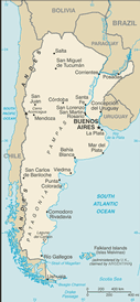
Argentina! Physical Geography
Area-total: 2,780,400 sq km
land: 2,736,690 sq km
water:43,710 sq km
Argentina is slightly less than three-tenths the size of the US
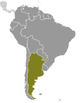
Land boundaries-total: 9,861 km
border countries:Bolivia 832 km, Brazil 1,261 km, Chile 5,308 km, Paraguay
1,880 km, Uruguay 580 km
Coastline:4,989 km
Climate-mostly temperate; arid in southeast; subantarctic in southwest
Terrain-rich plains of the Pampas in northern half, flat to rolling plateau of Patagonia in south, rugged Andes along western border
Elevation extremes-lowest point: Laguna del Carbon -105 m (located between Puerto San
Julian and Comandante Luis Piedra Buena in the province of Santa Cruz)
highest point:Cerro Aconcagua 6,960 m (located in the northwestern
corner of the province of Mendoza)
land: 2,736,690 sq km
water:43,710 sq km
Argentina is slightly less than three-tenths the size of the US
Land boundaries-total: 9,861 km
border countries:Bolivia 832 km, Brazil 1,261 km, Chile 5,308 km, Paraguay
1,880 km, Uruguay 580 km
Coastline:4,989 km
Climate-mostly temperate; arid in southeast; subantarctic in southwest
Terrain-rich plains of the Pampas in northern half, flat to rolling plateau of Patagonia in south, rugged Andes along western border
Elevation extremes-lowest point: Laguna del Carbon -105 m (located between Puerto San
Julian and Comandante Luis Piedra Buena in the province of Santa Cruz)
highest point:Cerro Aconcagua 6,960 m (located in the northwestern
corner of the province of Mendoza)
|
